BMW 5 Series: Traffic bulletins
 BMW 5 Series: Traffic bulletins
- At a glance
- Switching the reception on/off
- Opening the traffic bulletins
- Traffic bulletins on the map
- Filtering traffic bulletins
- Destination guidance with traffic bulletins
At a glance
▷ Display the traffic bulletins from radio stations that broadcast the TI Traffic Information of a traffic information service. Information on traffic obstructions and hazards is updated continuously.
Certain BMW models equipped with navigation have the capability to display realtime traffic information. If your system has this capability the following additional terms and conditions apply:
An End-User shall no longer have the right to use the Traffic Data in the event that the End-User is in material breach of the terms and conditions contained herein.
A. Total Traffic Network, a division of Clear Channel Broadcasting, Inc. (“Total Traffic Network”) holds the rights to the traffic incident data and RDS-TMC network through which it is delivered. You may not modify, copy, scan or use any other method to reproduce, duplicate, republish, transmit or distribute in any way any portion of traffic incident data. You agree to indemnify, defend and hold harmless BMW of North America, LLC. (“BMW NA”) and Total Traffic Network, Inrix, Inc (and their affiliates) against any and all claims, damages, costs or other expenses that arise directly or indirectly out of (a) your unauthorized use of the traffic incident data or the RDS-TMC network, (b) your violation of this directive and/or (c) any unauthorized or unlawful activities by you in connection herewith.
B. Total Traffic Network traffic data is informational only. User assumes all risk of use.
Total Traffic Network, BMW NA, and their suppliers make no representations about content, traffic and road conditions, route usability, or speed.
C. The licensed material is provided to licensee “as is,” and “where is”. Total Traffic Network, including, but not limited to, any and all third party providers of any of the licensed material, expressly disclaims, to the fullest extent permitted by law, all warranties or representations with respect to the licensed material (including, without limitation, that the licensed material will be errorfree, will operate without interruption or that the traffic data will be accurate), express, implied or statutory, including, without limitation, the implied warranties of merchanta particular purpose, or those arising from a course of dealing or usage of trade.
D. Neither Total Traffic Network, Inrix, Inc. or BMW NA will be liable to you for any indirect, special, consequential, exemplary, or incidental damages (including, without limitation, lost revenues, anticipated revenues, or profits relating to the same) arising from any claim relating directly or indirectly to use of the traffic data, and even if Total Traffic Network, Inrix, Inc., or BMW NA are aware of the possibility of such damages. These limitations apply to all claims, including, without limitation, claims in contract and tort (such as negligence, product liability and strict liability).
Some states do not allow the exclusion or limitation of incidental or consequential damages, so those particular limitations may not apply to you.
▷ The traffic bulletins are indicated on the map
by symbols.<>
▷ The traffic bulletins for the surrounding area
are stored in a list.<>
 The symbol in
the function bar of the map
view turns red if there are traffic bulletins
that affect the calculated route.
The symbol in
the function bar of the map
view turns red if there are traffic bulletins
that affect the calculated route.
Switching the reception on/off
1. "Navigation"
2. "Options" Open.
3. "Receive Traffic Info"
Opening the traffic bulletins
1. "Navigation"
2. "Map"
3.  "Traffic Info"
First the traffic bulletins for the calculated
route are displayed. The traffic bulletins are
sorted by their distance from the current position
of the vehicle.
4. Select a traffic bulletin.
 "More information": display
additional
information.
"More information": display
additional
information.
5. Scroll to the next or previous traffic bulletin
if required.
Traffic bulletins on the map
"Traffic conditions/gray map" Active: indication on the control display is switched to shades of gray. This enables a better view of the traffic bulletins. Day/night mode is not taken into account in this setting. Symbols and special destinations are not displayed.
1. "Navigation"
2. "Map"
3. "Options" Open.
4. "Settings"
5. "Traffic conditions/gray map"
Symbols in the map view
Depending on the scale of the map and the location of the traffic obstruction along the route, the symbols for the traffic obstructions are displayed.
Additional information in the map view
tion's length, direction, and impact are displayed in the map using triangles or gray bars along the calculated route.
▷ Red: congestion.
▷ Orange: stop-and-go traffic.
▷ Yellow: heavy traffic.
▷ Green: clear roads.
▷ Gray: general traffic bulletins, e.g., construction
site.
The displayed information depends on the particular traffic information service.
Filtering traffic bulletins
You can set which traffic bulletins appear on the map.
1. "Navigation"
2. "Map"
3. "Options" Open.
4. "Traffic Info categories"
5. Select the desired categories.
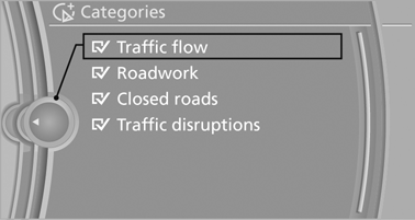
Traffic bulletins of the selected category are displayed on the map.
▷ Traffic bulletins that are relevant to the route
are always shown.
▷ For your own safety, traffic bulletins that notify
you of potentially dangerous situations,
such as wrong-way drivers, cannot be hidden.
Destination guidance with traffic bulletins
Detour suggestions from the navigation system can be manually accepted in the semi-dynamic destination guidance. In the dynamic destination guidance, they are automatically accepted in the route guidance.
Semi-dynamic destination guidance
When traffic bulletin reception is switched on, semi-dynamic destination guidance is active.
The destination guidance system takes the available traffic information into account. A message is displayed depending on the route, the traffic bulletins, and the possible detour routes.
When there is a traffic obstruction, if possible, a detour is offered. In addition, distance and time differences between the original route and the detour are displayed.
To accept the detour:
 "Detour"
In the event of special hazards, e. g., objects on the road, a message is displayed without a detour suggestion.
Detours can also be accepted if the traffic messages are called up in the list.
1. "Navigation"
2. "Map"
3.  "Traffic Info"
4. "Detour information"
5.  "Detour"
Dynamic destination guidance
The route is automatically changed in the event of traffic obstructions.
▷ The system does not point out traffic obstructions
along the original route.
▷ Traffic bulletins continue to be displayed on
the map.
▷ Depending on road type and the kind and
extent of the traffic obstruction, the calculated
route may lead through the traffic obstruction.
▷ Dangerous situations are displayed regardless
of the setting.
To activate dynamic destination guidance:
1. "Navigation"
2. "Options" Open.
3. "Dynamic guidance"